Meet the EA's Agricultural Remote Sensing Team
An overview of the work of the EA's Agricultural Remote Sensing Team.
Remote Sensing – what is it and how do we use it?
Remote sensing refers to a range of digital and satellite imaging and Artificial Intelligence tools that we use for our work regulating agriculture.
The team undertake catchment wide surveys identify potential pollution risks from farming and associated land management practices.
We also provide support to our regulatory officers by providing reports that aid them when they carry out farm inspections.
Image
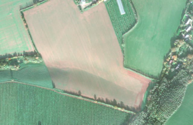
Image showing an erosion rill caused by runoff and soil loss.
How do we use remote sensing tools?
- We use these technologies for a range of different purposes: Verifying pollution incidents – we can capture pollution occurring using satellite images. We can see erosion caused by run-off and overland flows of pollutants or discolouration of watercourses resulting from pollution
- Assessing catchment-wide potential pollution risks from issues such as a lack of cover crops during winter months or inappropriate siting of outdoor pigs near watercourses
- We can capture evidence that helps our officers understand the extent and seriousness of a pollution incident that has been reported
- Pre-Farm inspection reports – we provide our officers with remote sensing reports for farms they are inspecting; this can help identify potential risks or land management issues
- Slurry storage capacity – we can remotely assess the capacity of slurry storage and estimate if there is sufficient capacity
- We can measure changes in landscape and farm infrastructure over time.
- Identifying slurry spreading from satellite imagery
- Identifying crops which are deemed to be risky when grown in certain locations and on certain soil types, such as maize and potatoes
- We are continually evolving and seeking out new technologies and ways we can use remote sensing to ensure we are an efficient and effective regulator
Image
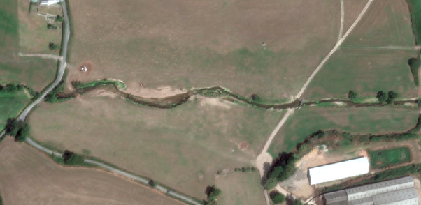
Image showing poaching and riverbank damage caused by livestock access to the river.